
The Vale Airfield is a 1300m grass runway running parallel to the Dasher River in NorthWest Tasmania. It is situated only a couple of nautical miles from a beautiful mountain, Mount Roland.
This 4000ft granite beast dominates the local view all the way to the nearby town of Sheffield. It is part of a system of ridge systems that give way to the Tasmanian Central Plateau. The Plateau is a large, gorgeous and pristine alpine and lake region that includes the world famous Cradle Mountain national park.
Over the last several months, I’ve been using Pipistrel Taurus G2 electric self-launch motor glider to gradually (and carefully) explore this complex, fascinating, and beautiful area from the air, through a variety of weather conditions. The conclusion I’ve reached is that we are fortunate indeed, to have an airfield that is surely one of the best places in Tasmania to fly gliders.
There are many opportunities to go soaring here, using a wide variety of ‘lift’ mechanisms enabled by this fascinating and complex terrain – and to do it all year round!
What follows is a study in the successful use of the three major ways to sustain soaring flight in gliders, in flights were conducted over three successive days at The Vale, in three distinct weather systems.
Lets start with an annotated Google Earth image of the local area from the point of view of a soaring pilot (click image to enlarge) and then we’ll turn to Day One:
(The orange dotted lines are some of the local area ridge lines)

Day One: Mountain Lee Wave Soaring
One of the most wonderful ways to go soaring in a glider is the use of ‘Mountain Lee Waves’.
Wave (in this context) refers to a large standing-wave that forms in the atmosphere downstream (to the Lee) of a large physical feature (such as a mountain) in the presence of a strong and consistent wind that increases in strength with increasing height.
Mountain waves can extend into the sky to heights that are multiples of the height of the ground feature that triggers them. What forms in the air is an ‘echo’ of the shape of the ground feature, high up in the sky, with the into-wind side being a tide of rising air that can be surfed in a glider, to gain height.
Even better: If the wind keeps getting stronger with height, the primary wave system can act like another mountain! One wave can trigger another wave system, located further downwind and higher than the primary wave. This can keep happening, with multiple wave systems capable of ‘stacking up’ in a rising sequence.
Clouds can form in the middle of a wave system, appearing in a classic “Lenticular” shape, being quite literally ‘polished’ by the air rotating around the wave core. In the presence of multiple secondary waves, there can be a ‘stack’ of these lenticular clouds.
On the day we flew, there were no lenticular clouds to indicate the presence of the wave system… it was still there, but it was invisible.
However, I had another way to find the wave. I used a fabulous soaring pilots’ weather prediction application called Skysight.
Skysight has access to global, high accuracy weather forecasting data and it uses this data and a great deal of smart number-crunching to generate predictive, visual, forecasts for glider pilots. These forecasts help them to predict (with high accuracy in both space and time) the presence of various distinct sorts of weather systems that can be used to sustain soaring flight.
You can explore these images (generated by Skysight) to see what I mean:
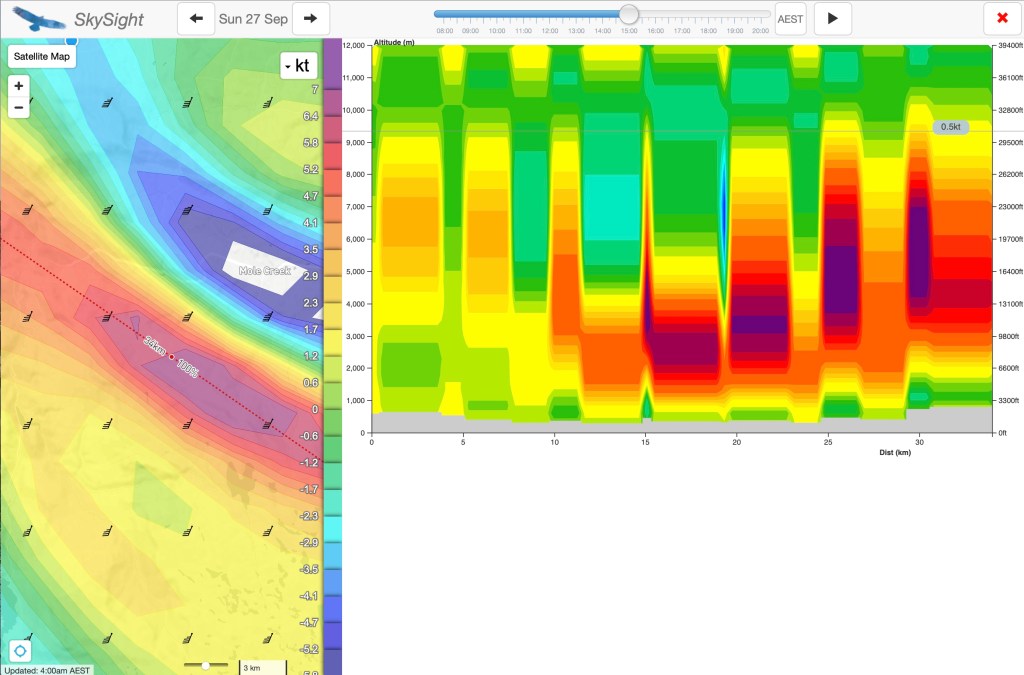
The Skysight model for wave showed multiple significant wave zones at increasing heights 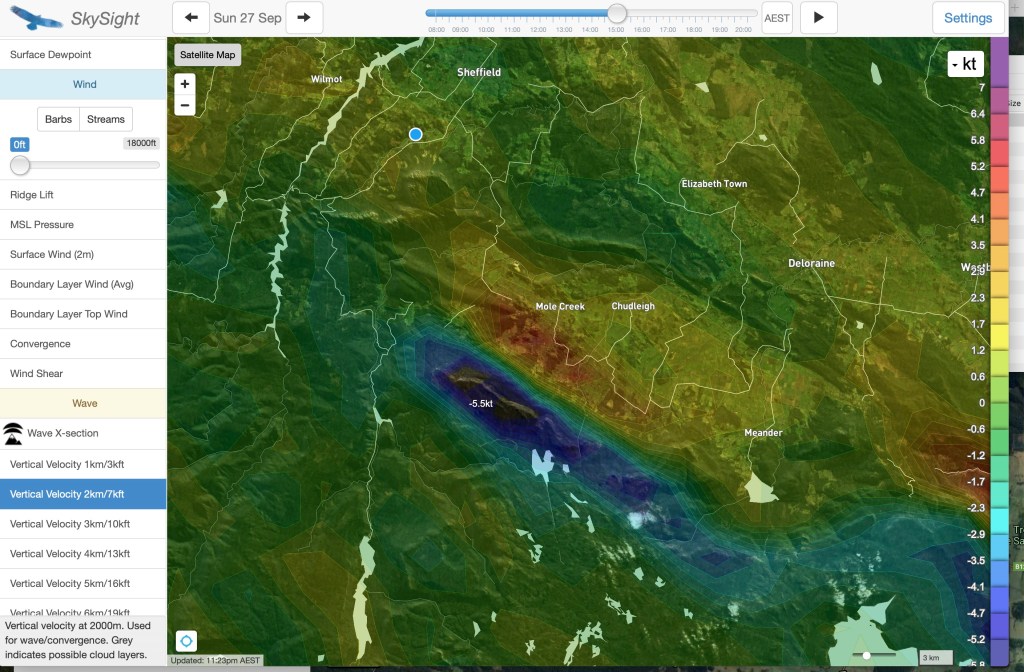
The primary wave prediction for 7000kt shows lift over the with a zone of sink beyond it, pver the central plateau edge 
At 23000ft, the Skysight wave model shows the large secondary wave system positioned further south, over the central plateau 
This image shows just how close the The Vale is to multiple nearby wave systems.
As per those images, the Skysight model showed the presence of a substantial primary wave system above 5000 feet, then extending through multiple secondary wave systems all the way up to over 20,000 feet (!).
It turns out that this wave system sets up quite frequently in Tasmania in the cooler months.
An impressive example of this happened back on 12th April 2020. This was not a day that I could fly (darn). Have a look (below) at just how impressive the wave system was, right across Tasmania. Lennies very much in evidence in the sky to go with it. A soaring pilot could have hopped from wave to wave, literally across the entire state.
Stacked Lenticular Clouds over Mole Creek 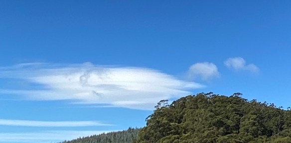
Stacked Lenticular Clouds (detail) 
Wave over Mole Creek 
Wave in the Vicinity of The Vale 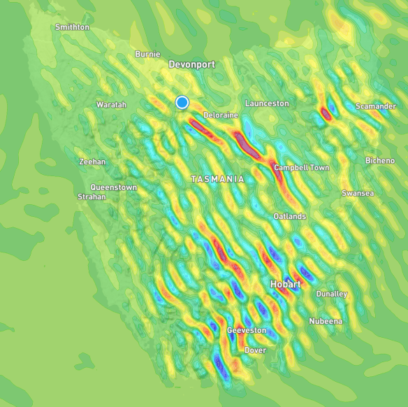
Wave over the whole of Tasmania
Back to the present – and with my son Gabe as our photographer and co-pilot, it was time to see if the computer model was accurate in telling us that the wave was there, even though the indicator clouds were not.
To help us to find this quite invisible lift system, it was time to engage another piece of technology, the LX9000 soaring glass-cockpit system in my glider. The LX9000 is an incredible instrument. One of its plethora of features is the ability to import Skysight predictive map overlays directly onto the device for display in flight.
This means that I could fly the glider with the wave predictive model ‘on screen’, so we could fly under power up to the height and position needed to contact the wave system, and then shut down the motor and start playing.
We did precisely this. We climbed to about 5000 feet and flew to the edge of the predicted lift zone, and shut down the engine. As if by magic – there it was, and we just starting going up.
Here’s what the Skysight wave overlay looks like in the LX, in flight, in the aircraft. On the image, the lift zone is the yellow/orange/red zone on the map.
This photo was taken at a later point, when we had already climbed in wave up to over 9000 feet:

Wave lift is wonderful – it is a smooth, quiet journey of exploration, quietly working your way back and forth along the lift band.
Being a system driven entirely by wind, wave conditions can be (and mostly are) present in the depths of winter, when flat-land glider pilots have given up gliding for the season due to the lack of any useable thermals.
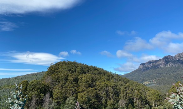
We flew the glider up and down the Mole Creek Valley on our climb, and wound up high over the edge of the Central Plateau. The Plateau was covered in a layer of snow from the previous night, and it looked rugged and wonderful.
Here’s are some images from the wave flight:

Batteries fully charged and ready to go 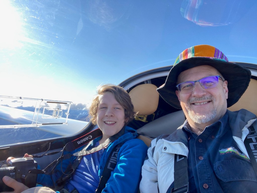
Wave soaring expedition underway Successfully working the primary wave system with the Skysight predictive model overlaid on the LX9000 
The high country with recent snowfall around Lake MacKenzie 
Central Plateau shrouded in snow 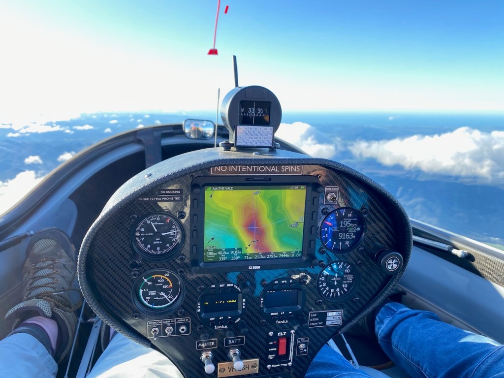
Wave soaring in clear air, above the clouds 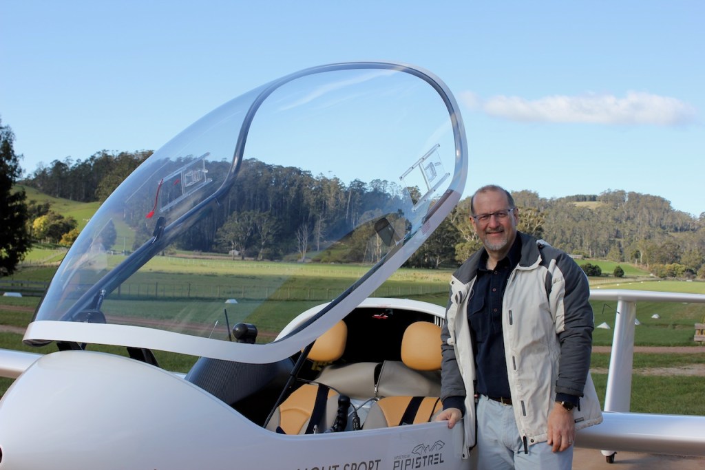
Author after a successful wave flight 
The Central Plateau rises beyond the Mole Creek Valley 
The Taurus Electric Drive System is visible in the mirror 
The central plateau features rugged terrain high above forest valleys 
Soaring above the clouds in the sunshine 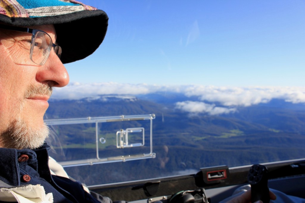
Heading back toward Mount Roland from Mole Creek 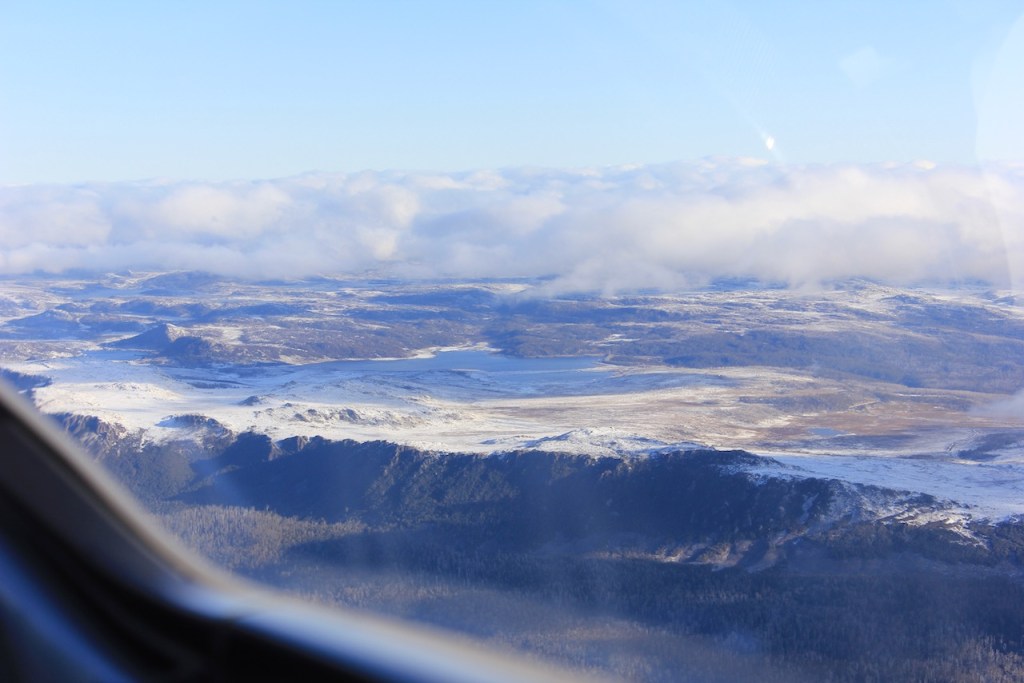
Central Plateau Cliffs
(Photo credit for many of these images: Gabe Hackett)
The next post will be about Day Two of Three when the wind moderated, the sun came out, and the lift was there again – but this time it was Thermals.

You must be logged in to post a comment.